编写程序导入文本文件到空间数据库中。 
1、创建一个File Geodatabase 2、创建一个FeatureClassgeometry类型为esriGeometryType.esriGeometryPoint、采用esriSRGeoCSType.esriSRGeoCS_NAD1983坐标系统该FeatureClass的属性字段包含经度、纬度以及State_Name字段。 3、使用CreateFeature/Store将文本文件中的数据信息导入到FearureClass使用IFeatureCursor/IFeatureBuffer也可以进行同样的操作。 4、使用usa.mxd中的图层更新“State_Name”字段。
作答
1.在自定义的CreateFields函数里创建字段集
//在CreateFields函数里创建字段集public IFieldsEdit CreateFields(){//使用编辑接口IFieldEdit(IFieldsEdit)创建新的Field对象或新的Fields集//创建字段集合. 使用IFieldsEdit接口要将Field对象加入到Fields集中//IFields pFields new FieldsClass();//IFieldsEdit pFieldsEdit pFields as IFieldsEdit;IFieldsEdit pFields new FieldsClass(); //等同上面两句 //创建字段Object ID必要字段 使用IFieldEdit接口可为新的字段设定名字、数据类型、长度等属性IFieldEdit pField new FieldClass();pField.Name_2 "ObjectID";pField.Type_2 esriFieldType.esriFieldTypeOID;pFields.AddField(pField);//创建完数据集需要的每个pField后要把它们加入到pFields集中//创建几何定义//IGeometryDef pGD new GeometryDefClass();//IGeometryDefEdit pGDE pGD as IGeometryDefEdit; IGeometryDefEdit pGDE new GeometryDefClass();//等同于上面两句pGDE.GeometryType_2 esriGeometryType.esriGeometryPoint;//☆geometry类型也可以是Point,Polyline,Polygon//创建地理坐标系 使用esriSRGeoCSType,esriSRGeoCS2Type或esriSRGeoCS3Type枚举中的元素作为gcsType来创建地理坐标系ISpatialReferenceFactory pSRF new SpatialReferenceEnvironmentClass();esriSRGeoCSType geoSystem esriSRGeoCSType.esriSRGeoCS_NAD1983;//☆选择坐标系类型ISpatialReferenceResolution pSRR pSRF.CreateGeographicCoordinateSystem(Convert.ToInt32(geoSystem)) as ISpatialReferenceResolution;pSRR.ConstructFromHorizon(); //定义此空间参照的XY分辨率和域范围(基于其地平线的范围)ISpatialReferenceTolerance pSRT pSRR as ISpatialReferenceTolerance;//访问空间信息和M偏差pSRT.SetDefaultXYTolerance(); //设置用于控制X和Y尺寸中的点合并的默认簇公差 (相当于当前空间参考单位中的1mm)ISpatialReference pSR pSRR as ISpatialReference;pGDE.SpatialReference_2 pSR; //创建字段ShapepField new FieldClass();pField.Name_2 "Shape";pField.Type_2 esriFieldType.esriFieldTypeGeometry;pField.GeometryDef_2 pGDE;pFields.AddField(pField);//创建字段经度pField new FieldClass();pField.Name_2 "Longtitude";pField.Type_2 esriFieldType.esriFieldTypeDouble;pFields.AddField(pField);//创建字段纬度pField new FieldClass();pField.Name_2 "Latitude";pField.Type_2 esriFieldType.esriFieldTypeDouble;pFields.AddField(pField);//创建字段 小光光pField new FieldClass();pField.Name_2 "小光光";pField.Type_2 esriFieldType.esriFieldTypeString;pField.Length_2 25;pFields.AddField(pField);return pFields;}
2.创建File Geodatabase、FeatureClass
//创建File Geodatabase//file geodatabase需要引用Geodatabase、DataSourcesGDB,DataSourcesFileIWorkspaceFactory pWF new FileGDBWorkspaceFactoryClass();//IWorkspaceFactory接口使用Create方法生成WorkspaceName对象IWorkspaceName pWN pWF.Create("文件路径","文件名称.gdb",null,0);//使用IName接口上的Open方法将WorkspaceName实例化成WorkspaceIName pName pWN as IName;IWorkspace pWS pName.Open() as IWorkspace;//创建要素集FeatureClass 在FileGDBWorkspace上使用IFeatureWorkspace接口下的CreateFeatureClass方法创建新的要素集生成FileGDBIFeatureWorkspace pFW pWS as IFeatureWorkspace;IFeatureClass pFC pFW as IFeatureClass;IFieldsEdit pFields CreateFields();//在创建新的FeatureClass前需要为新的要素集创建字段集; 在CreateFields函数里创建了字段集pFC pFW.CreateFeatureClass("FClassName",pFields,null,null,esriFeatureType.esriFTSimple,"Shape",null); //创建要素集
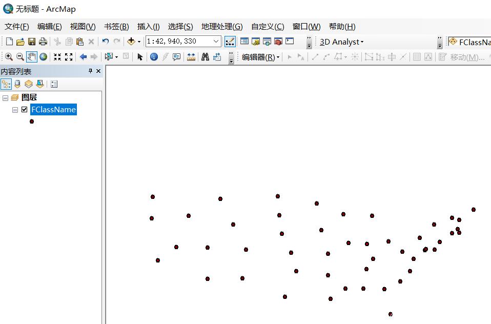
创建完成的File Geodatabase 和 要素集FeatureClass 图示帮助理解 
 3.使用 CreateFeature/Store或IFeatureCursor/IFeatureBuffer 将文本文件中的经纬度坐标导入到FeatureClass中
/---------------------------- --------------------------------//使用CreateFeature/Store将文本文件中的经纬度坐标导入到FeatureClass中//读取Txt文件System.IO.FileStream FS new System.IO.FileStream("文本文件地址",FileMode.Open);StreamReader SR new StreamReader(FS);while (!SR.EndOfStream){string[] Fields SR.ReadLine().Split(new char[] {,});//生成点状要素IPoint pPoint new PointClass();pPoint.X double.Parse(Fields[0]);//☆文本字段索引值根据情况更改pPoint.Y double.Parse(Fields[1]);//使用用CreateFeature/Store将坐标Feature加入到FeatureClass里这个坐标点可以显示IFeature pFea pFC.CreateFeature();pFea.Shape pPoint; //让点显示出来//pFea.set_Value(2,Fields[0]); //2是字段经度的索引值 Fields[0]是文本中的第一个值//pFea.set_Value(3,Fields[1]); //3是字段纬度的索引值 Fields[1]是文本中的第二个值pFea.set_Value(pFea.Fields.FindField("Longtitude"),Fields[0]);//FindField返回经度Longtitude在表中的索引值pFea.set_Value(pFea.Fields.FindField("Latitude"),Fields[1]);pFea.Store();/* 使用IFeatureCursor/IFeatureBuffer向要素集FeatureClass中插入数据 这个坐标点没显示IFeatureCursor pFCur pFC.Insert(true);IFeatureBuffer pFB pFC.CreateFeatureBuffer();pFB.set_Value(2, Fields[0]);pFB.set_Value(3, Fields[1]);pFCur.InsertFeature(pFB); //FeatureCursor的InsertFeature方法*/}SR.Close();FS.Close();
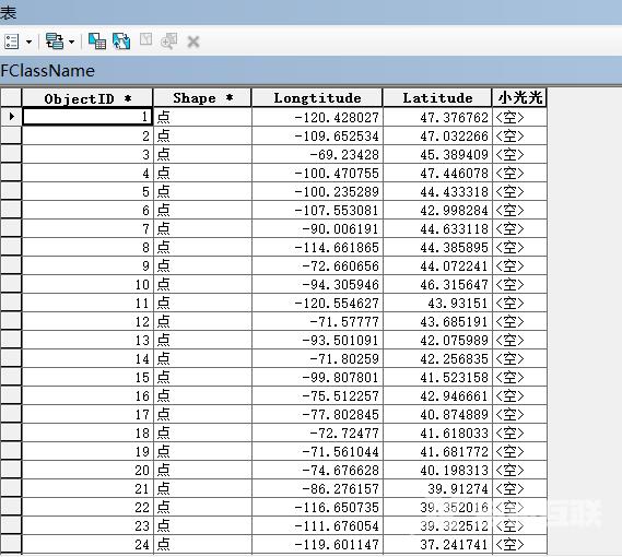
将经纬度坐标信息导入到FeatureClass中 图示 
 4.根据mxd中的图层表的字段值 来更新FeatureClass表中的"小光光"字段属性值
-------------------------------------------------------/////根据mxd中的图层更新FeatureClass表中的"小光光"字段属性值IFeatureLayer pFL1 axMapControl1.get_Layer(0) as IFeatureLayer;IFeatureClass pFC1 pFL1.FeatureClass; //要素图层States的FeatureClass1表IQueryFilter pQF new QueryFilterClass();IFeatureCursor pFCur1 pFC.Update(pQF,false); //更新FeatureClass表的字段IFeature pFea1 pFCur1.NextFeature(); //表FeatureClass中的Feature1while (pFea1 ! null){ISpatialFilter pSF new SpatialFilterClass();pSF.Geometry pFea1.Shape;pSF.SpatialRel esriSpatialRelEnum.esriSpatialRelWithin; //空间查询类型位于 pSF.WhereClause "";IFeatureCursor pFCur2 pFC1.Search(pSF,true); //在要素图层States的FeatureClass1表中查询IFeature pFea2 pFCur2.NextFeature();//.set_Value(attribureIndex,attributeValue)//获取要素图层States的第4个字段State_Name的各个Feature值 添加到 FeatureClass表字段是"小光光"的索引位置pFea1.set_Value(pFea1.Fields.FindField("小光光"),pFea2.get_Value(3).ToString());pFea1.Store();pFea1 pFCur1.NextFeature();}axMapControl1.ActiveView.Refresh();MessageBox.Show("Create file geodatabase successfully!");
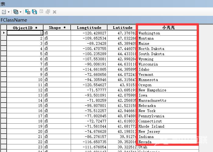
FeatureClass表中的"小光光"字段 更新 图示 
参考文章https://blog.csdn.net/Domen_Dragon/article/details/86515494
【本文由:盐城网站制作 http://www.1234xp.com/yancheng.html 欢迎留下您的宝贵建议】