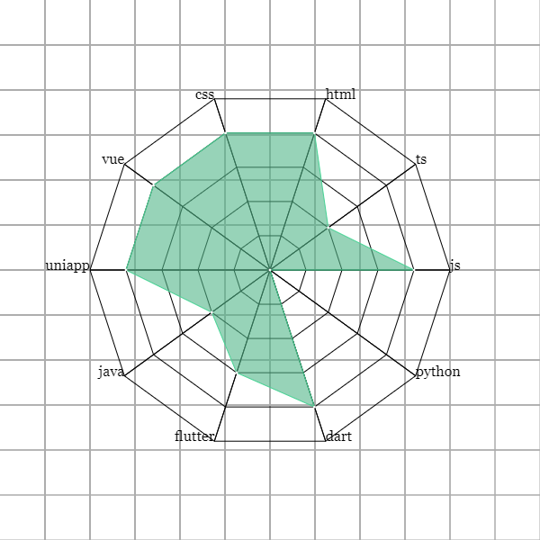
在《Canvas 线性图形(五):多边形》实现了绘制多边形的函数。本篇文章将记录如何绘制雷达图。最终实现的效果是这样的:
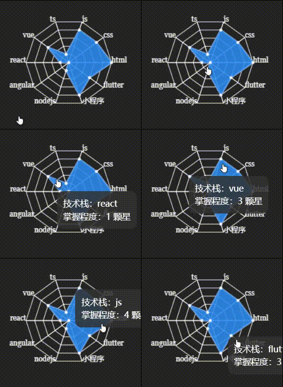
如动图中所示,雷达图从里到外一共有 6 层,所以,我们需要改造绘制多边形的函数:
点击查看绘制基础雷达图代码
function calcPolygonX(radarX, radius, increaseAngle) {
	return radarX + radius * Math.cos(increaseAngle);
}

function calcPolygonY(radarY, radius, increaseAngle) {
	return radarY - radius * Math.sin(increaseAngle);
}

// 绘制多边形的函数
function drawPolygon(radarMapTotalSides, radius, radarX, radarY, ctx) {
	let averageAngle = Math.PI * 2 / sides;
	let increaseAngle = 0;
	let targetX, targetY;

	ctx.beginPath();
	for ( let i = 0; i < radarMapTotalSides; i++ ) {
		targetX = calcPolygonX(radarX, radius, increaseAngle);
		targetY = calcPolygonY(radarY, radius, increaseAngle);
		ctx.lineTo(targetX, targetY);
		increaseAngle += averageAngle;
	}

	ctx.closePath();
	ctx.stroke();
}

// 绘制雷达图的函数
function drawRadarMap(radarLayers, polygonPerStep, radarMapTotalSides, radarX, radarY, ctx) {
	let radius = polygonPerStep;

	for ( let j = 0; j < radarLayers; j++ ) {
		drawPolygon(radarMapTotalSides, radius, radarX, radarY, ctx);
		radius = radius + polygonPerStep;
	}
}
polygonPerStep的意思是每一个多边形之间相差多少距离,radarMapTotalSides的意思是雷达图的多边形是几边形:
let canvas = document.getElementById("radar-map");
let ctx = canvas.getContext("2d");
drawRadarMap(5, 40, 10, 300, 300, ctx);
到目前为止我们就利用绘制多边形的函数drawPolygon成功绘制了一个雷达图的雏形:
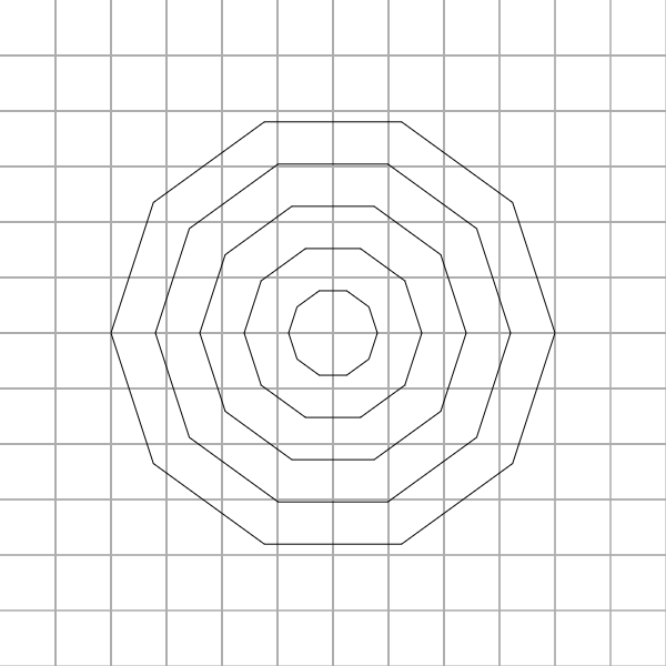
当前的雷达图还缺少了最外层每一个点的文本,以及连接雷达图中心到最外层点的直线。
连接雷达图里外层连接雷达图里外层时,要在绘制多边形的时候保存每一层每一个点的坐标,也就是在drawPolygon函数中保存坐标信息。
在drawRadarMap函数里面声明一个数组axis数组,它专门用于保存每层多边形的每个点坐标信息:
function drawRadarMap(radarLayers, polygonPerStep, radarMapTotalSides, radarX, radarY, ctx) {
	let axis = []; // 用于保存每一个多边形的每一个点坐标
	let radius = polygonPerStep;

	for ( let j = 0; j < radarLayers; j++ ) {
		drawPolygon(radarMapTotalSides, radius, radarX, radarY, axis, j, ctx);
		radius = radius + polygonPerStep;
	}
}
从顺时针开始的第一个点的坐标到最后一个点坐标,以及这些点坐标在第几层多边形上:
function drawPolygon(radarMapTotalSides, radius, radarX, radarY, axis, currentPolygonLayer, ctx) {
	let averageAngle = Math.PI * 2 / sides;
	let increaseAngle = 0;
	let targetX, targetY;

	ctx.beginPath();
	axis.push({ layer: currentPolygonLayer, coords: [] }); // 保存点坐标的数组,
	for ( let i = 0; i < radarMapTotalSides; i++ ) {
		targetX = calcPolygonX(radarX, radius, increaseAngle);
		targetY = calcPolygonY(radarY, radius, increaseAngle);
		ctx.lineTo(targetX, targetY);
		increaseAngle += averageAngle;
		axis[currentPolygonLayer].coords.push({ x: targetX, y: targetY }); // 添加点坐标到数组中
	}

	ctx.closePath();
	ctx.stroke();
}
drawPolygon函数新增了两个参数:axis 和 currentPolygonLayer。axis 就是保存没层多边形点的坐标数组;currentPolygonLayer 就是当前多边形在第几层多边形,比如第一层就是 0。
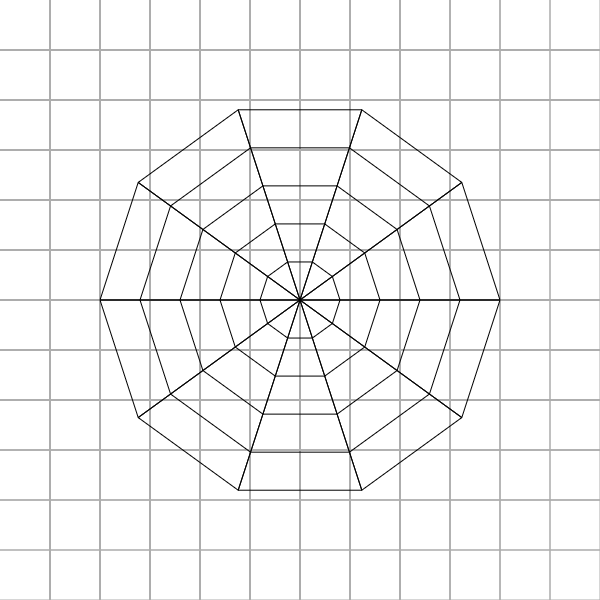
上面的工作是点坐标,目的就是连接雷达图中心点到最外层多边形的每一个点。所以,在这里我们新增一个函数,这个函数专门处理连接直线的函数drawStria:
function drawStria(radarLayers, axis, radarX, radarY, ctx) {
	let coords = axis[axis.length - 1].coords;
	for ( let i = 0; i < radarLayers; i++ ) {
		ctx.beginPath();
		ctx.moveTo(radarX, radarY);
		ctx.lineTo(coords[i].x, coords[i].y);
		ctx.closePath();
		ctx.stroke();
		drawPointText(data, coords, i, radarX, ctx);
	}
}
axis[length - 1].coords代表雷达图中最外层的多边形的所有点坐标。顺时针遍历其中元素,ctx.lineTo(coords[i].x, coords[i].y)从圆点开始依次连接最外层的多边形的点,从而构成一条条直线。
 绘制雷达图外层文本
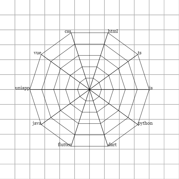
在雷达图最外层的多边形的每一个点添加文本,表示直线代表的是什么数据。
function drawPointText(data, axis, currentPoint, radarX, ctx) {
	ctx.font = `16px Georgia`;
	if ( axis[i].x <= radarX ) {
		ctx.textAlign = "right";
	} else {
		ctx.textAlign = "left";
	}
	ctx.fillText(data[currentPoint].title, axis[currentPoint].x, axis[currentPoint].y);
}
对于这个函数的几个参数讲解:
- data:顺时针开始最外层每一个点的文本;
- axios:最外层多边形每一个点的坐标信息;
- currentPoint:当前循环到的多边形的一个点坐标;
- radarX:雷达图中心坐标的 x 坐标轴。
在drawStria函数循环体内调用该函数完成最外层的文本渲染:
 绘制数据区域
接下来就是雷达图最重要的部分了。雷达图中每一条直线上该文本所达到的值在此直线上进行移动,连接这些点构成一块区域,就是数据区域。
点击查看绘制数据区域的完整代码
function calcDataAreaTopX(areaTopLayer, axis, radarX, currentPoint) {
	if ( areaTopLayer < 0 ) {
		return radarX;
	} else {
		return axis[areaTopLayer].coords[currentPoint].x;
	}
}

function calcDataAreaTopY(areaTopLayer, axis, radarY, currentPoint) {
	if ( areaTopLayer < 0 ) {
		return radarY;
	} else {
		return axis[areaTopLayer].coords[currentPoint].y;
	}
}

function drawDataAreaTop(axis, currentPoint, radarX, radarY, ctx) {
	let x = calcDataAreaTopX(data[currentPoint].star - 1, axis, radarX, currentPoint);
	let y = calcDataAreaTopY(data[currentPoint].star - 1, axis, radarY, currentPoint);
	if ( i === 0 ) {
		ctx.moveTo(x, y);
	} else {
		ctx.lineTo(x, y);
	}
	return { x: x, y: y };
}

function drawDataArea(radarMapTotalSides, radius, axis, radarX, radarY, data, ctx) {
	ctx.beginPath();
	for ( let i = 0; i < radarMapTotalSides; i++ ) {
		drawDataAreaTop(axis, i, radarX, radarY, ctx);
	}
	ctx.closePath();
	ctx.strokeStyle = "rgba(68,226,155, 1)";
	ctx.stroke();
	ctx.fillStyle = "rgba(81,182,137, 0.6)";
	ctx.fill();
}
需要为数据函数提供一个data,这个是数据区域的信息,最外层多边形每一个点对应的值:
点击查看数据区域的数据
let data = [
    {
      title: "js",
      star: 4
    },
    {
      title: "ts",
      star: 2
    },
    {
      title: "html",
      star: 4
    },
    {
      title: "css",
      star: 4
    },
    {
      title: "vue",
      star: 4
    },
    {
      title: "uniapp",
      star: 4
    },
    {
      title: "java",
      star: 2
    },
    {
      title: "flutter",
      star: 3
    },
    {
      title: "dart",
      star: 4
    },
    {
      title: "python",
      star: 0
    }
];
以上就是绘制数据区域的函数的完整代码。drawDataAreaTop是圈画数据区域的函数,而drawDataArea完成最后的颜色填充工作。drawDataAreaTop接收以下几个参数:
- axis:顺时针开始最外层每一个点的文本;
- currentPoint:当前循环到的多边形的一个点坐标;
- radarX:雷达图中心坐标的 x 坐标轴;
- radarY:雷达图中心坐标的 y 坐标轴。
这里需要特别说明data[currentPoint].star - 1,因为 star 是从 0 开始,最大值为 5,必须要减 1,不然数组索引值越界。
在绘制雷达图的函数下面添加drawStria和drawDataArea两个函数,完整一个完整的雷达图绘制
function drawRadarMap(radarLayers, polygonPerStep, radarMapTotalSides, radarX, radarY, ctx) {
	// ...
	// ...

	drawStria(radarMapTotalSides, axis, radarX, radarY, ctx);
	drawDataArea(radarMapTotalSides, axis, radarX, radarY, data, ctx);
}

drawRadarMap(5, 40, 10, 300, 300, ctx);
雷达图浮动面板Gitee 仓库-雷达图完整代码
这一节是扩展雷达图的功能,当鼠标浮在数据区域节点之上时,就出现一个浮动面板,展示具体的数据信息。浮动面板和雷达图被包裹在一个 div 标签里,并设置为相对定位,浮动面板设置为绝对定位。
<div id="radar-wrap">
	<canvas id="radar-map" width="400" height="400">Your browser version is too late.</canvas>
	<div id="floating-panel"></div>
</div>
点击查看 CSS 代码
#radar-map {
    cursor: pointer;
    position: absolute;
    border: 1px solid rgba(110, 110, 110, 0.8);
    border-radius: 10px;
}

#radar-wrap {
    width: 400px;
    height: 400px;
    box-sizing: border-box;
    position: relative;
}

#floating-panel {
    position: absolute;
    display: none;
    border-style: solid;
    white-space: nowrap;
    z-index: 9999999;
    transition: left 0.4s cubic-bezier(0.23, 1, 0.32, 1) 0s, top 0.4s cubic-bezier(0.23, 1, 0.32, 1) 0s;
    background-color: rgba(50, 50, 50, 0.7);
    border-width: 0;
    border-color: rgb(51, 51, 51);
    border-radius: 4px;
    color: rgb(255, 255, 255);
    font: 14px / 21px "Microsoft YaHei";
    padding: 5px;
    left: 29px;
    top: 145px;
    pointer-events: none;
}
接下来就是最重要的 JS 代码,这里为了方便控制样式,我就用 JQuery 来实现。这里需要改造一下drawDataArea函数,我们要保存数据区域每一个点的坐标。
点击查看 JQuery 代码
drawFloatingPanel(axis) {
	let floatingPanel = $("#floating-panel");
	let timeout = null;
	$("#radar-map").on({
		mousemove: function (e) {
			if ( timeout != null ) clearTimeout(timeout);
			timeout = setTimeout(() => {
				axis.forEach((value, index) => {
					if ( (value.x >= e.offsetX - 5 && value.x < e.offsetX + 5) && (value.y >= e.offsetY - 5 && value.y < e.offsetY + 5) ) {
						$(floatingPanel).css({
							"display": "block", "left": `${ e.offsetX }px`, "top": `${ e.offsetY }px`
						});
						$(floatingPanel).empty().append(`
							<div class="tech">技术:${ value.title }</div>
							<div class="star">掌握程度:${ value.star } 颗星</div>
						`);
					}
				});
			}, 50);
		},
		mouseleave: function (e) {
			$(floatingPanel).css({ "display": "none" });
		}
	});
};
Gitee 仓库-雷达图浮动面板完整代码
