目录 需求 解题思路 解题方法 最终效果 需求 ui设计稿给了一张下面这张图,背景图用线条画出来的, 心里也是...,没办法也是要实现出来。 解题思路 1.思路一 在canvas外层添加一个d
目录
- 需求
- 解题思路
- 解题方法
- 最终效果
需求
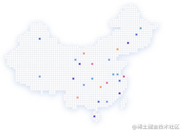
- ui设计稿给了一张下面这张图,背景图用线条画出来的, 心里也是...,没办法也是要实现出来。

解题思路
1.思路一
在canvas外层添加一个div背景图用上面的图片,然后把map地图背景图调成透明,这种方法有很大问题,就是后面怎么做hover显示不同的省份,怎么做缩放呢,难不成还要监听canvas的组件事件来缩放div,所以果断放弃。
2.思路二
仔细观察这张图是不是有规律的,它是一个一个小方格组成的就像贴地板砖一样,那我是不是可以利用地图的纹理来做文章,经过查找Echart api 正好有设置纹理的配置,赞。
解题方法
1.标准动作一
先找ui切个"地板砖",地板转如下图 (ps:地板砖有点小哈)

2.标准动作二
在代码html里面增加img标签 设置图片为切好的地砖
  <div class="graph-chart-wrap">
    <div class="graph-chart" ref="graph"></div>
    <img ref="image" style="width:10px"  v-show="false" src="/assets/image/public/repeat2.png" alt />
  </div>
在定义options的上面获取img
const dom = this.$refs["image"];
配置options
     geo: {
        map: 'china',
        show: true,
        roam: true,
        label: {
          normal: {
            show: true
          },
          emphasis: {
            show: true
          }
        },
        type: "map",
        geoIndex: "1",
        zoom: 1.2,
        itemStyle: {
          normal: {
            areaColor: {
              image: dom, // 这里是引用上面的img html
              repeat: "repeat" // 地板是重复铺贴吗
            },
            borderColor: "rgba(0,0,0,0.2)"
          },
          emphasis: {
            areaColor:'#69a5ff',
            color: "#fff"
          },
          label: {
            show: false
          },
          shadowColor: 'rgba(0, 0, 0, 1)',
          shadowBlur: 100
        }
      },
全部代码
<template>
  <div class="graph-chart-wrap">
    <div class="graph-chart" ref="graph"></div>
    <img ref="image" style="width:10px"  v-show="false" src="../../../../assets/image/public/repeat2.png" alt />
  </div>
</template>
<script lang="ts">
import { Component, Vue } from 'vue-property-decorator';
import * as echarts from 'echarts';
import { getTreemap } from '@/api/home';
import { fontSize } from '@/utils/index';
const echartMapJSON = require('@/assets/map/china.json');


@Component({
  name: 'graph',
  components: {}
})
export default class extends Vue {
  private dataList = [];
  mounted() {
    this.getTreemap();

    setInterval(() => {
      this.getTreemap();
    }, 60000);
    this.createChart();
  }

  private async getTreemap() {
    const res = await getTreemap();
    if (res && res.data.code === 200) {
      this.dataList = res.data.data;
    }
  }

  private createChart() {
    const GeoCoordMap: any = {
      北京市: [116.4551, 40.2539],
      辽宁: [123.1238, 42.1216],
      重庆: [108.384366, 30.439702],
      浙江: [119.5313, 29.8773],
      福建: [119.4543, 25.9222],
      广东: [113.12244, 23.009505],
      上海: [121.4648, 31.2891]
    };
    const data = [
      { name: '北京', value: 199 },
      { name: '天津', value: 42 },
      { name: '河北', value: 102 },
      { name: '山西', value: 81 },
      { name: '内蒙古', value: 47 },
      { name: '辽宁', value: 67 },
      { name: '吉林', value: 82 },
      { name: '黑龙江', value: 123 },
      { name: '上海', value: 24 },
      { name: '江苏', value: 92 },
      { name: '浙江', value: 114 },
      { name: '安徽', value: 109 },
      { name: '福建', value: 116 },
      { name: '江西', value: 91 },
      { name: '山东', value: 119 },
      { name: '河南', value: 137 },
      { name: '湖北', value: 116 },
      { name: '湖南', value: 114 },
      { name: '重庆', value: 91 },
      { name: '四川', value: 125 },
      { name: '贵州', value: 62 },
      { name: '云南', value: 83 },
      { name: '西藏', value: 9 },
      { name: '陕西', value: 80 },
      { name: '甘肃', value: 56 },
      { name: '青海', value: 10 },
      { name: '宁夏', value: 18 },
      { name: '新疆', value: 180 },
      { name: '广东', value: 123 },
      { name: '广西', value: 59 },
      { name: '海南', value: 14 }
    ];
    const colorList = [
      '#5776DE','#709EED','#6434D5','#E26395','#E8A057','#6434D5'
    ]

    const convertData = (data: any) => {
      let res = [];
      for (let i = 0; i < data.length; i++) {
          const geoCoord = GeoCoordMap[data[i].name];
          if (geoCoord) {
              res.push({
                  name: data[i].name,
                  value: geoCoord.concat(data[i].value)
              });
          }
      }
      return res;
    };

    const dom = this.$refs["image"];

    let options: any = {
      title: {
        top: 20,
        // text: '“会员活跃度” - 山东省',
        subtext: '',
        x: 'center',
        textStyle: {
          color: '#fff'
        }
      },
      tooltip: {
        trigger: 'item',
        backgroundColor:'#fff',
        className: 'echarts-tooltip echarts-tooltip-dark echarts-tooltip-user',
        borderColor:'#e6e6e6',
        padding: 4,
        triggerOn:'click'
      },
      geo: {
        map: 'china',
        show: true,
        roam: true,
        label: {
          normal: {
            show: true
          },
          emphasis: {
            show: true
          }
        },
        type: "map",
        geoIndex: "1",
        zoom: 1.2,
        itemStyle: {
          normal: {
            areaColor: {
              image: dom,
              repeat: "repeat"
            },
            borderColor: "rgba(0,0,0,0.2)"
          },
          emphasis: {
            areaColor:'#69a5ff',
            color: "#fff"
          },
          label: {
            show: false
          },
          shadowColor: 'rgba(0, 0, 0, 1)',
          shadowBlur: 100
        }
      },
      series: [
        {
          symbolSize: 5,
          label: {
            normal: {
              formatter: '{b}',
              position: 'right',
              show: false
            },
            emphasis: {
              show: false
            }
          },
          itemStyle: {
            normal: {
              color: '#fff'
            }
          },
          name: 'light',
          type: 'scatter',
          coordinateSystem: 'geo',
          data: convertData(data)
        },
        {
          name: 'Top 5',
          type: 'effectScatter',
          coordinateSystem: 'geo',
          symbol: 'circle',
          symbolSize: [8, 8],
          itemStyle: {
            normal: {
              color:function(params:{ dataIndex: any }){
                return colorList[params.dataIndex]
              }
            }
          },
          data: convertData(data),
          showEffectOn: 'render',
          rippleEffect: {
            brushType: 'stroke'
          },
          hoverAnimation: true,
          zlevel: 1,
          tooltip: {
            formatter: function (params: { value: any[]; name: any; dataIndex: number }) {
              return `<div style="width: aoto;text-align:center;line-height:28px; height: auto;color:#fff;font-size: 10px; padding:5px;margin: 0;background:${colorList[params.dataIndex]};border-radius:10px">
              <p style="line-height:20px;padding:0;margin:0">${params.name}工厂线</p>
              <p style="line-height:20px;padding:0;margin:0">今日实时生产总数</p>
              <p style="line-height:20px;padding:0;margin:0">${params.value[2]}</p>
              </div>`
            },
            position:'top',
            backgroundColor:'#fff'
          }
        },
      ]
    };
    const graphChart = echarts.init(this.$refs.graph as HTMLCanvasElement);
    echarts.registerMap('china', echartMapJSON);
    graphChart.setOption(options);
    let len = -1;
    setInterval(() => {
      const dataLen = colorList.length;
      len = (len + 1) % dataLen;
      graphChart.dispatchAction({
        type: 'hideTip'
      });
      graphChart.dispatchAction({
        type: 'showTip',
        seriesIndex: 1,
        dataIndex: len
      });
    }, 2000);
  }
}
</script>
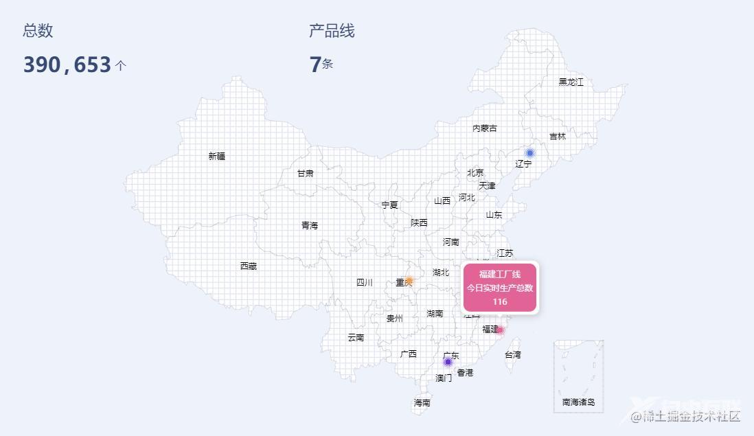
最终效果

到此这篇关于Echart中国地图更换背景图的方法示例的文章就介绍到这了,更多相关Echart更换背景图内容请搜索自由互联以前的文章或继续浏览下面的相关文章希望大家以后多多支持自由互联!
